


L'Aubaret pic cassini

Alain28/01
User
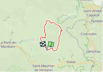

Length
19.2 km

Max alt
1673 m

Uphill gradient
517 m
Km-Effort
26 km

Min alt
1249 m

Downhill gradient
514 m
Boucle
Yes
Creation date :
2024-04-15 21:16:36.882
Updated on :
2024-04-15 21:17:45.165
5h55
Difficulty : Difficult

FREE GPS app for hiking
 SityTrail
IGN / Geographical institutes
SityTrail Plus
The world is yours!
About
Trail Walking of 19.2 km to be discovered at Occitania, Lozère, Pont de Montvert - Sud Mont Lozère. This trail is proposed by Alain28/01.
Positioning
Country:
France
Region :
Occitania
Department/Province :
Lozère
Municipality :
Pont de Montvert - Sud Mont Lozère
Location:
Saint-Maurice-de-Ventalon
Start:(Dec)
Start:(UTM)
566812 ; 4911342 (31T) N.
Comments